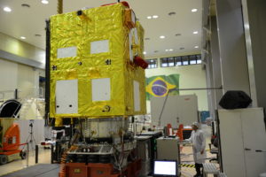
By the end of 2019, Brazil and China will launch CBERS-4a, the sixth satellite in the China-Brazil Earth Resources Satellite (CBERS) programme that this year celebrates 20 years since the first, CBERS-1, was sent to space.
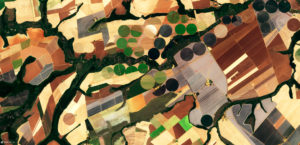
CBERS-4a’s mission is to extend and technologically upgrade a programme whose main success has been helping Brazil combat deforestation in the Amazon and other vulnerable biomes by providing real-time images of fires and other causes of forest loss.
Using data from CBERS satellites, the Brazilian National Space Research Institute (INPE) announced recently that deforestation rates in the Amazon rose 88% between June 2018 and the same month this year, the highest in years. In a rare attack on the integrity of INPE’s work, Jair Bolsonaro’s ministers suggested the latest figures may have been manipulated.
With the president politicising environmental protection by cutting funding for public agencies that fight deforestation, the continuation of the CBERS programme represents a slice of hope in efforts to protect the Amazon.
“It is a long-term programme, and an example of the need for public policies designed for the long term, beyond the next election and beyond politics and parties,” said Mauricio Santoro, a professor of international relations at Rio de Janeiro State University.
Technological and environmental gains
Since its creation, the China-Brazil satellite programme has allowed the South American country to make great strides in monitoring deforestation. It provides information to supervisory bodies that can even enable them to catch culprits in the act.
CBERS assists remote sensing systems that monitor intentional forest fires and greenhouse gas emissions (GHGs).
1988
the year China and Brazil agreed to cooperate on space research
CBERS’ 1999 launch was a landmark event in a space cooperation partnership that began a decade earlier. Despite a 30-year history, it was only in 2004 that INPE decided to make the CBERS images public.
While the move made satellite images available for a range of social initiatives, it was also a response to strong private sector demand. For example, the monitoring system allows farmers to identify pests.
“How much is worth to a farmer to see whether diseases are attacking [crops]?” Claudio Almeida, INPE’s programme coordinator for monitoring the Amazon and other biomes, asked rhetorically.
Almeida said the images have reached municipaland state governments, and academic institutions, improving the quality of their research.
“[The programme] has allowed us to grow technologically.
The new CBERS-4a version is lighter, has a longer lifespan (five years instead of three), four cameras, and more advanced technology capable of storing more data and producing higher-resolution images than previous versions. This will enables it to produce more detailed images of areas affected by deforestation — which can help detect problems better and more quickly.
CBERS-4a is expected to have completed testing by the middle of next year, by which time it will have already begun recording more detailed images Amazon deforestation than ever before.
Brazil is currently also preparing its own satellite, the Amazonia-1, for launch in 2020, which will monitor deforestation and the growth of agriculture.
Trade war
The news of the sixth China-Brazil satellite comes as Brazil agreed a new space partnership with the US at the Alcântara base in Maranhão State in Brazil’s northeast.
This agreement was interpreted by some as an message from the US to China, which also has a controversial space base in Argentina.
Santoro said the two projects are entirely unrelated, despite Bolsonaro’s desire to align Brazil more closely with the US politically.
“The US and Brazil tried to come to an agreement on Alcântara 20 years ago,” he said, adding; “The thinking was that Brazil would gain more from a more horizontal and less asymmetrical relationship.”
Gilberto Camara, director of the Group on Earth Observations (GEO), said the space programme was a way China could relate to international partners at a high level.
“This is important from a diplomacy point of view.I It is a positive agenda,” he said.
In a statement issued to Diálogo Chino, the Brazilian Space Agency said that current tensions between the US and China over trade would not affect Brazil’s satellite programme and that projects “have objectives of interest to all humanity, collecting and distributing information for open use.”
Launching a partnership
Brazil and China’s space cooperation boosted a relationship between countries that were politically aligned in the 1970s but which hadn’t yet developed a significant trading relationship, according to Santoro.
“[It] became the largest programme for scientific and technological cooperation among developing countries in the 1980s and 1990s,” he said.
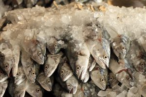
Today, Brazil is China’s main supplier of food, the production of which is responsible for Brazil’s largest share of overall greenhouse gas emissions. Industrial agriculture also has significant impacts on water and soil.
Though the trade in agricultural products it is a fundamental part of the relationship, the satellite programme demonstrates that China values its cooperation with Brazil beyond it being a provider of food, Santoro said.